Nov 17, 2013 Severe Weather Outbreak, White County, Indiana EF-2 Tornado
November 21, 2013 1 Comment
November severe weather. How often does that happen? Not much for full outbreaks. This is an account of my adventure into a rare High risk severe weather outlook in mid-November.
We left from Mount Pleasant at 7am Sunday, dark and early. The air was cool, but a warmer wind blew as I crossed the parking lot with 4 items under my arms and on my back. Two cameras, a tripod, backpack with instruments, and a laptop. Our destination was unknown at the time. We had a goal to reach South Bend, IN as this was a reasonable distance to travel and still be within an area of elevated severe chances. We went through all sorts of data on the trip down. It all gets overwhelming and at some point you just need to let it happen.
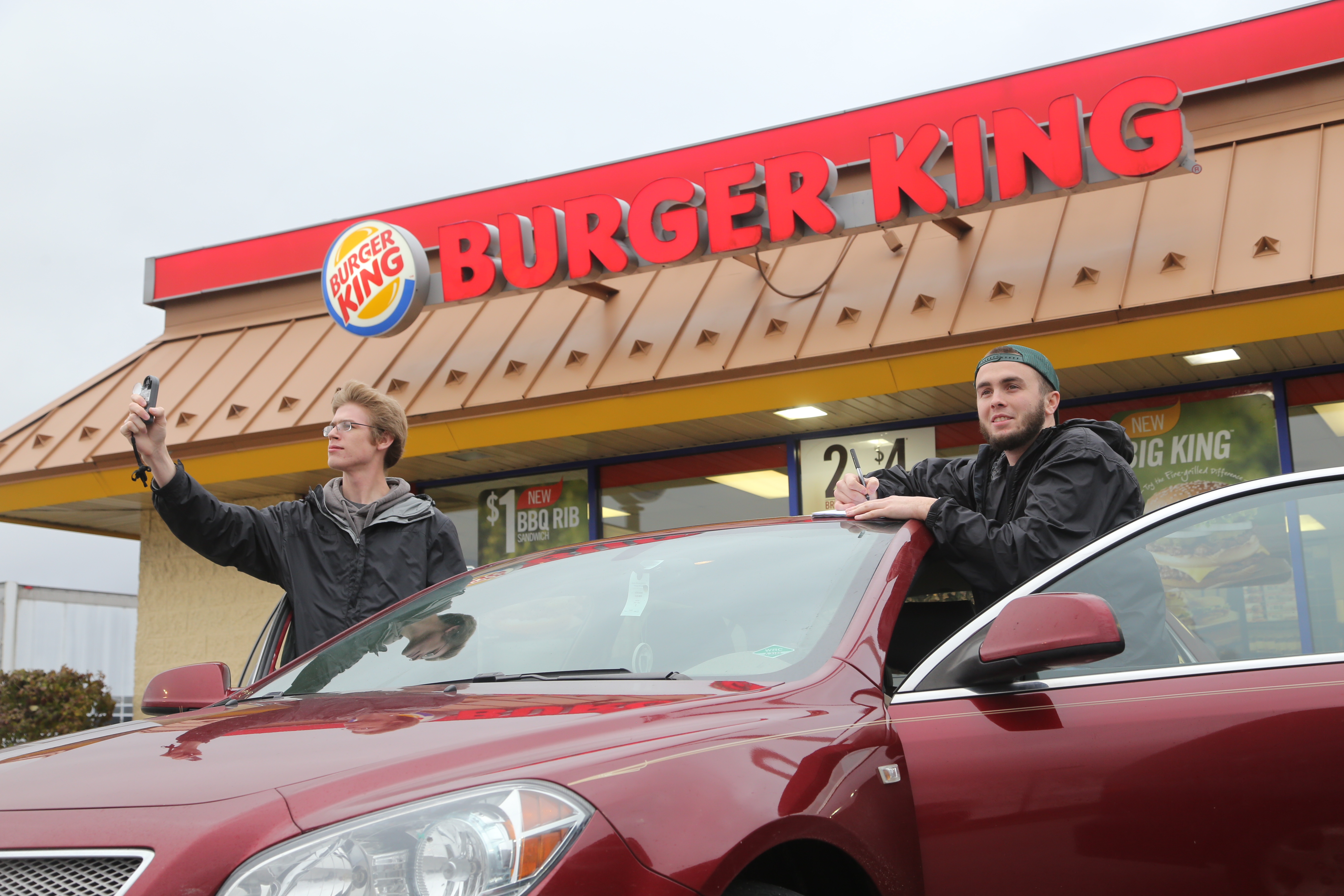
We took a pit stop at a BK. Kevin and Bryan take notes on current conditions before heading further south.
We reached South Bend and carried on. At this time, storms were firing in central Illinois. We stopped at a fast food restaurant and used some stronger Wifi. About this time the Peoria, IL storm was really cranking up. The storm showed strong structure and looked to remain on a fixed path towards Chicago. Things could go sour fast. This was the EF-4 tornado that affected Washington, IL, carving a large scar through a populated area. From our current spot, we had no chance in intercepting this storm as some of these were moving to the northeast as fast as 60 mph! As we went south, wooded areas became fields with only pockets of trees.

From the NWS in Chicago, IL. Note the cell that has a hook-echo signature near Peoria, IL and continues NE where it impacted Washington, IL as an EF-4.
As we traveled south, the area of storms started to fill in from single cells, to a uniform line. This was bad news if seeking tornadoes. Usually large and strong tornadoes spawn from single power-hungry supercells so they have no neighbors to compete for energy, or be bothered by outflow winds. A line of storms meant winds would be straight and not possibly rotating, thus little chance at a tornado. The line directly to our west was filling in to just be severe thunderstorm level winds and heavy rains. We had a new goal of intercepting a cell coming from Champaign, IL. The cell had exhibited rotation from central Illinois, and had been tornado warned earlier.
We continued to race south on I-65. Towards central Indiana, 65 starts slightly curving to the east so that it goes trough Lafayette, IN. This bought us some time and we found ourselves immersed in a large wind farm. We exited I-65 at the SR-18 interchange. There we sat for about a half hour to assess storm motion. Looking at the storm, we noted the good structure had diminished and it could just form into a line of high winds instead. Storms moving through Lafayette were looking enticing, but there was no way we would make it down there in time. So this was it. We made our way back towards the interchange and sat pointed west, awaiting our prize.

Turbines lined the road in front of us. These closest ones were the last to disappear in front of our eyes.
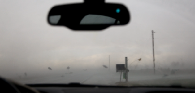
Being in a large wind farm, we could see turbines disappearing in the heavy rain as the line approached. We enjoyed that as entertainment, helping heal the wound of not finding a tornado after a long travel. It traveled quickly. One turbine gone, and then the next. Then the wall of rain and wind hit us. It immediately reminded me of hurricane videos. My ears popped from pressure change, which was really weird when you are used to that happening changing altitude. Rain was being whipped around in sheets and you could see no further then 10 feet in front of our car. Grass was mimicking the behavior as it was whipped around. This was probably enhanced by the lack of any large objects to block the wind. The wind was traveling over clean and flat farmland for acres in our W and SW direction. It quickly became frightening. Although it didn’t seem much different from a squall line in Michigan. Some other things suddenly became realized.

I looked down to my phone with the current radar displayed. We had underestimated the storm’s strength and organization due to poor storm velocity data outside of radar range. This is called range folding. Range folding is purposefully put in place on weather radar to prevent having a false signal reported, so it helps accuracy within reliable ranges. We decided to set up shop in a spot of ambiguity between two nearby radar sites. This is a big no-no as we had virtually been blind.
After a moment of panic in the car with the suddenness of wind and blinding rain, it quickly got worse. New radar scans came in and the velocity image showed a spot of rotation making its way straight for our area. The signature was not a strong tight rotation typically associated with tornadoes, but given the environment we were in, there could be a rain-wrapped tornado on track to us.Fear continued to sink in.
This is NOT how you chase/spot/report severe weather.
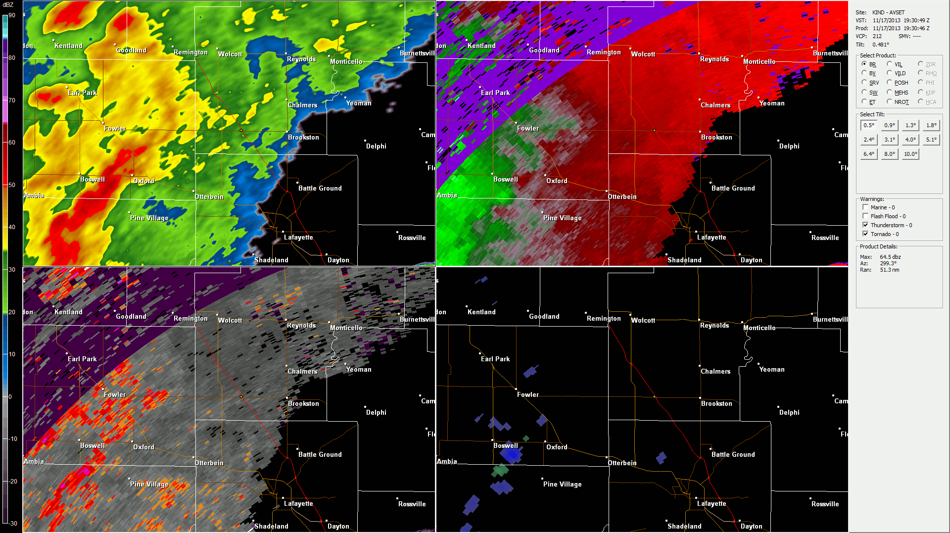
Our location, marked by a yellow cross, with reflectivity, velocity, spectrum width, and rotation radar overlays. CLICK for ANIMATION and larger.
Winds seemed to calm a bit, I could see further out the side window, at least the field to the north 20 yards away. We discussed the ears popping and how much the pressure needed to change for that to happen. We had Kestrel devices with us, so we could check that later. At this point we were furiously waiting for radar scans to come in and keep us updated. The winds began to increase again. They got stronger then when the storm began. Rain caused a complete whiteout and I could no longer see anything out of the window, front or sides.

Lighting was quick, bright, and frequent. The car began rocking like a boat. Sharp clatter prompted Bryan to call to duck our heads. Debris began a migration across the road in front and behind us, maybe even over us. Lots of twisted sheet metal tumbled by like pieces of paper. Then, it was done.
A car drove through behind the wall of rain, like some sheep dog corralling a heard. Sheet metal continued to carry on a path across the road from south to north. Pieces lined a wire fence nearby. We waited for remaining lightning to stop while rear flank winds licked at our car. Once it was safe, we emerged and checked the car. No damage at all. The van that had been behind us checked on us and drove on, wiping his arm across his forehead with relief. Mammatus filled the sky as the system moved out. We could also make out a beaver tail of clouds flanking the storm.
We got very lucky. Once things calmed down, I called a report of a possible rain-wrapped tornado to the National Weather Service in Indianapolis (we were actually in Northern Indiana’s forecast area, but they forwarded the report). We found other evidence when investigating to the southwest. A few barns had been destroyed and a roof removed from a house. Photos can be found in this Flickr album.
20:09 13 NW LAFAYETTE POSSIBLE RAIN WRAPPED TORNADO. SHEET METAL CAUGHT IN A FENCE. NEAREST BUILDINGS ACROSS A FIELD A FEW ACRES AWAY.
With the Canon 6D, all of my photos were geotagged. This made it easy to document where we were relative to the damage we found, and to further report to the NWS.

Example of some photos geotagged to a map in Lightroom. Very handy to have for documentation!
The National Weather Service in Northern Indiana confirmed a EF-2 tornado with max wind speeds of 125mph near our location. You can read the full writeup including more maps and radar imagery on their event summary page, which included 15 tornadoes from EF-0 to EF-2 across their forecast area alone!
RATING: EF-2
MAXIMUM ESTIMATED WIND SPEED: 125 MPH
MAXIMUM ESTIMATED PATH WIDTH: APPROXIMATELY 1400 YARDS
PATH LENGTH: 9.52 MILES (LONGER IF YOU INCLUDE BENTON COUNTY
SECTION)
START TIME: ESTIMATED AROUND 246 PM EST
END TIME: ESTIMATED AROUND 255 PM EST
LOCATION: ENTERED WHITE COUNTY NEAR BENTON/WHITE/TIPPECANOE COUNTY
BORDER. LIFTED APPROXIMATELY 2 MILES WNW OF BROOKSTON.
DESCRIPTION: CONTINUED FROM BENTON COUNTY. VERY WIDE CIRCULATION
WITH EMBEDDED VORTICIES. 20 TO 25 BARNS DESTROYED WITH DEBRIS THROWN
UP TO 2 MILES AWAY. 10 TWO FOOT DIAMETER WOODEN ELECTRICITY POLES
SNAPPED AT THE BASE. SMALL HOME HAD ITS ROOF COMPLETELY REMOVED WITH
THE DEBRIS THROWN UP TO HALF A MILE NORTHEAST. SECTIONS OF THE ROOF
WERE STUCK IN THE GROUND LIKE PROJECTILES.
Again, we were super fortunate to drive away from this. There is so much to pour over and be thankful for. Witnessing the damage done by these storms is shocking, and I can’t imagine what places like Washington, Illinois looks like first hand. My thoughts go to those who have lost all.
Other sites with storm review:
EDIT:
Some track maps were released earlier Friday and the picture is a bit clearer where the exact path went, just across a field south of our position at the I-65 and 18 interchange.

